Cyclone Fani set to make landfall near Puri around 9:30 am Friday, here are 10 points to know
The Meteorological Department said Cyclone Fani is the first cyclonic storm of such severity in April in India's oceanic neighbourhood in 43 years.
Published: 03rd May 2019 01:43 AM

Latest image of cyclone Fani as per NASA Hurricane. (Photo | NASA Hurricane Twitter)
By Online Desk
The extremely severe cyclonic storm Fani is expected to make its landfall on Friday morning around 9.30 am close to Odisha's Puri, much before the earlier forecast of 3 pm. These districts--Puri, Jagatsinghpur, Kendrapara, Bhadrak, Balasore, Mayurbhanj, Gajapati, Ganjam, Khordha, Cuttack and Jajpur--are likely to bear the brunt of the cyclone. It may hit 10,000 villages and 52 towns in total.
Extremely heavy rainfall is likely in coastal and interior Odisha, north Andhra Pradesh, and West Bengal on Friday. There are huge storm surge and flooding risks for coastal Odisha and West Bengal, and also for Bangladesh.
As Fani heads towards the eastern coast, the Indian Coast Guard has positioned 34 disaster relief teams at different spots and deployed four ships to handle any exigency. The Odisha government Thursday issued instructions to shift women in their advanced stage of pregnancy to nearby hospitals.

Here are ten points to know ahead of Fani's landfall:
ONE OF A KIND: Fani is billed as the most severe cyclonic storm since the super cyclone of 1999 that claimed close to 10,000 lives and left a trail of destruction in vast swathes of Odisha, according to the Joint Typhoon Warning Centre. The Meteorological Department said it is the first cyclonic storm of such severity in April in India's oceanic neighbourhood in 43 years. Formation of such cyclonic storm during summer is very rare as the phenomenon is generally witnessed after monsoon in September-November.
GLOBAL WARMING: Former Director of the Regional Meteorological Centre, Bhubaneswar, Sarat Sahu said Odisha witnessed cyclonic storms during summer in 1893, 1914, 1917, 1982 and 1989, but these brought little trouble for the state as they either fizzled out or changed course towards West Bengal. The cyclone has formed due to warming of the Bay of Bengal basin. "With global warming, we have to be prepared for such occurrences," Sahu said.
WIND SPEED: Fani's wind speed is expected to be between 170 and 180 km an hour, which can even reach up to 200 km when it makes the landfall around 9.30 am. Landfall process is likely to take place over 5 hours.
TO CROSS BENGAL: After crossing Odisha, the cyclone is likely to move towards West Bengal before tapering off. Private weather forecaster Skymet said, after making landfall near Puri district on May 3, Fani will move north-northeast through Gangetic West Bengal. However, by the time Fani will reach West Bengal, it will have weakened into a cyclonic storm.

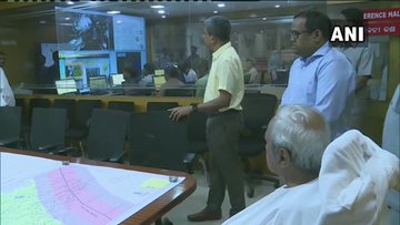

ANI
✔@ANI
CMO Odisha: CM Naveen Patnaik visited Special Relief Organisation office to review preparedness, and appealed to people to remain indoors until #CycloneFani passes & advised all officials to make their best efforts to face the cyclone.
352
9:19 PM - May 2, 2019
63 people are talking about this
TRAINS AND FLIGHTS HIT: All flights from Bhubaneswar have been cancelled from Friday midnight. Kolkata airport will close at 9.30 pm on Friday until 6 pm on Saturday. The Railways has cancelled more than 200 trains that pass along the coast. Some of the trains which have been cancelled include Howrah-Chennai Central Coromandal Express, Patna-Eranakulam Express, New Delhi-Bhubaneswar Rajdhani Express, Howrah-Hyderabad East Coast Express, Bhubaneswar-Rameswaram Express.
SCHOOLS AND COLLEGES SHUT: The higher education department has directed all state universities and colleges in Ganjam, Gajapati, Puri, Khurda, Nayagarh, Cuttack, Jajpur, Bhadrak, Kendrapara, Jagatsinghpur, Balasore and Mayurbhanj districts to remain closed for three days from May 2.
FORCES ON STANDBY: Around 900 cyclone shelters have been made ready to house evacuees while troops of the Indian Navy, Indian Coast Guard and 78 teams of the National Disaster response Force (NDRF) have been requisitioned for deployment.



Have a look at the roll being experienced by one of the ships deployed in the wake of #CycloneFani. Do notice the totally wet quarter deck..
.. Yes, its getting in and out of water view choppy seas around
406
6:29 PM - May 2, 2019
142 people are talking about this
WILL SOUTH FACE IMPACT? It is, however, still likely to impact parts of the northeast, Andhra Pradesh and Tamil Nadu. In Andhra Pradesh, the districts of Srikakulam, Vijayanagram and Visakhapatnam are likely to be affected.
ORANGE ALERTS: IMD has issued orange alert for Gajapati, Ganjam, Puri, Khurda, Rayagada and Kandhamal districts on May 2 and red warning for 25 districts including Khurda, Cuttack, Jagatsinghpur, Jajpur, Puri, Bhadrak, Ganjam, Kendrapara, Balasore and Angul on May 3.
View image on Twitter


Doordarshan News
✔@DDNewsLive
#CycloneFani: Follow these DO's and DON'Ts to keep yourself safe
PC: @ndmaindia
136
11:08 AM - May 2, 2019
122 people are talking about this
RAIN FORECAST: While moderate rainfall will occur at most places, heavy to very heavy rainfall will occur at few places and extremely heavy rainfall will lash isolated places over the coastal region and adjoining districts of interior Odisha on May 3. The rainfall activity will continue with light to moderate rainfall occurring at most places and heavy to very heavy rainfall at isolated places over north Odisha on May 4.
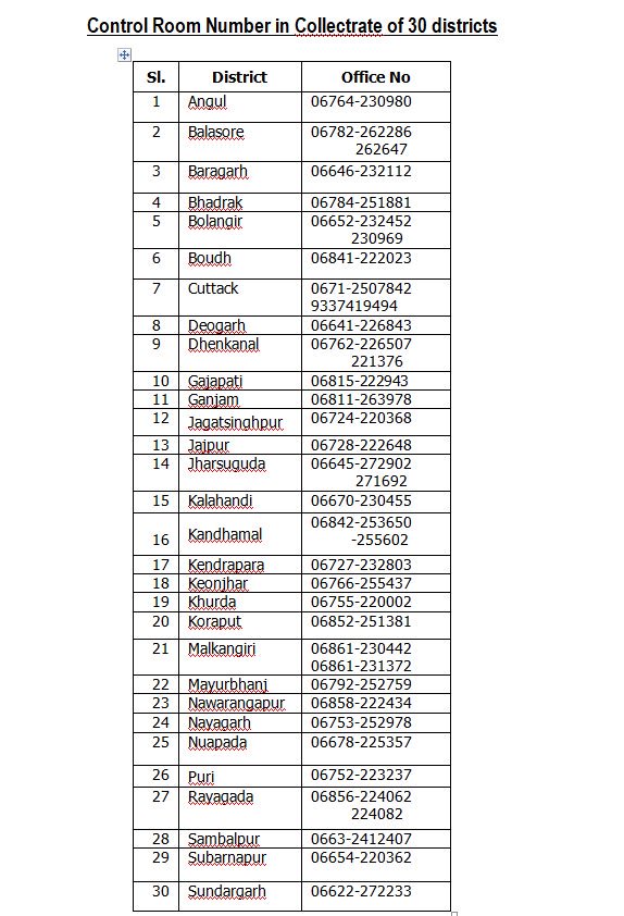
HELPLINE NUMBERS:
View image on Twitter

Doordarshan News
✔@DDNewsLive
Odisha’s emergency helpline number for Cyclone Fani +916742534177, Control room number of different districts have been issued #CycloneFani
176
8:32 PM - May 2, 2019
197 people are talking about this
Twitter Ads info and privacy
The Railways has released helpline numbers:
Bhubaneswar- (0674-2303060, 2301525, 2301625)
Khurda Road (0674-2490010, 2492511, 2492611)
Sambalpur (0663- 2532230, 2533037, 2532302)
Visakhapatnam – (0891- 2746255, 1072)
Puri- 06752-225922
Bhadrak- 06784-230827
Cuttack- 0671-2201865
Berhampur- 0680-2229632
The Meteorological Department said Cyclone Fani is the first cyclonic storm of such severity in April in India's oceanic neighbourhood in 43 years.
Published: 03rd May 2019 01:43 AM
Latest image of cyclone Fani as per NASA Hurricane. (Photo | NASA Hurricane Twitter)
By Online Desk
The extremely severe cyclonic storm Fani is expected to make its landfall on Friday morning around 9.30 am close to Odisha's Puri, much before the earlier forecast of 3 pm. These districts--Puri, Jagatsinghpur, Kendrapara, Bhadrak, Balasore, Mayurbhanj, Gajapati, Ganjam, Khordha, Cuttack and Jajpur--are likely to bear the brunt of the cyclone. It may hit 10,000 villages and 52 towns in total.
Extremely heavy rainfall is likely in coastal and interior Odisha, north Andhra Pradesh, and West Bengal on Friday. There are huge storm surge and flooding risks for coastal Odisha and West Bengal, and also for Bangladesh.
As Fani heads towards the eastern coast, the Indian Coast Guard has positioned 34 disaster relief teams at different spots and deployed four ships to handle any exigency. The Odisha government Thursday issued instructions to shift women in their advanced stage of pregnancy to nearby hospitals.
Here are ten points to know ahead of Fani's landfall:
ONE OF A KIND: Fani is billed as the most severe cyclonic storm since the super cyclone of 1999 that claimed close to 10,000 lives and left a trail of destruction in vast swathes of Odisha, according to the Joint Typhoon Warning Centre. The Meteorological Department said it is the first cyclonic storm of such severity in April in India's oceanic neighbourhood in 43 years. Formation of such cyclonic storm during summer is very rare as the phenomenon is generally witnessed after monsoon in September-November.
GLOBAL WARMING: Former Director of the Regional Meteorological Centre, Bhubaneswar, Sarat Sahu said Odisha witnessed cyclonic storms during summer in 1893, 1914, 1917, 1982 and 1989, but these brought little trouble for the state as they either fizzled out or changed course towards West Bengal. The cyclone has formed due to warming of the Bay of Bengal basin. "With global warming, we have to be prepared for such occurrences," Sahu said.
WIND SPEED: Fani's wind speed is expected to be between 170 and 180 km an hour, which can even reach up to 200 km when it makes the landfall around 9.30 am. Landfall process is likely to take place over 5 hours.
TO CROSS BENGAL: After crossing Odisha, the cyclone is likely to move towards West Bengal before tapering off. Private weather forecaster Skymet said, after making landfall near Puri district on May 3, Fani will move north-northeast through Gangetic West Bengal. However, by the time Fani will reach West Bengal, it will have weakened into a cyclonic storm.


ANI
✔@ANI
CMO Odisha: CM Naveen Patnaik visited Special Relief Organisation office to review preparedness, and appealed to people to remain indoors until #CycloneFani passes & advised all officials to make their best efforts to face the cyclone.
352
9:19 PM - May 2, 2019
63 people are talking about this
TRAINS AND FLIGHTS HIT: All flights from Bhubaneswar have been cancelled from Friday midnight. Kolkata airport will close at 9.30 pm on Friday until 6 pm on Saturday. The Railways has cancelled more than 200 trains that pass along the coast. Some of the trains which have been cancelled include Howrah-Chennai Central Coromandal Express, Patna-Eranakulam Express, New Delhi-Bhubaneswar Rajdhani Express, Howrah-Hyderabad East Coast Express, Bhubaneswar-Rameswaram Express.
SCHOOLS AND COLLEGES SHUT: The higher education department has directed all state universities and colleges in Ganjam, Gajapati, Puri, Khurda, Nayagarh, Cuttack, Jajpur, Bhadrak, Kendrapara, Jagatsinghpur, Balasore and Mayurbhanj districts to remain closed for three days from May 2.
FORCES ON STANDBY: Around 900 cyclone shelters have been made ready to house evacuees while troops of the Indian Navy, Indian Coast Guard and 78 teams of the National Disaster response Force (NDRF) have been requisitioned for deployment.


Have a look at the roll being experienced by one of the ships deployed in the wake of #CycloneFani. Do notice the totally wet quarter deck..
.. Yes, its getting in and out of water view choppy seas around
406
6:29 PM - May 2, 2019
142 people are talking about this
WILL SOUTH FACE IMPACT? It is, however, still likely to impact parts of the northeast, Andhra Pradesh and Tamil Nadu. In Andhra Pradesh, the districts of Srikakulam, Vijayanagram and Visakhapatnam are likely to be affected.
ORANGE ALERTS: IMD has issued orange alert for Gajapati, Ganjam, Puri, Khurda, Rayagada and Kandhamal districts on May 2 and red warning for 25 districts including Khurda, Cuttack, Jagatsinghpur, Jajpur, Puri, Bhadrak, Ganjam, Kendrapara, Balasore and Angul on May 3.
View image on Twitter


Doordarshan News
✔@DDNewsLive
#CycloneFani: Follow these DO's and DON'Ts to keep yourself safe
PC: @ndmaindia
136
11:08 AM - May 2, 2019
122 people are talking about this
RAIN FORECAST: While moderate rainfall will occur at most places, heavy to very heavy rainfall will occur at few places and extremely heavy rainfall will lash isolated places over the coastal region and adjoining districts of interior Odisha on May 3. The rainfall activity will continue with light to moderate rainfall occurring at most places and heavy to very heavy rainfall at isolated places over north Odisha on May 4.
HELPLINE NUMBERS:
View image on Twitter


Doordarshan News
✔@DDNewsLive
Odisha’s emergency helpline number for Cyclone Fani +916742534177, Control room number of different districts have been issued #CycloneFani
176
8:32 PM - May 2, 2019
197 people are talking about this
Twitter Ads info and privacy
The Railways has released helpline numbers:
Bhubaneswar- (0674-2303060, 2301525, 2301625)
Khurda Road (0674-2490010, 2492511, 2492611)
Sambalpur (0663- 2532230, 2533037, 2532302)
Visakhapatnam – (0891- 2746255, 1072)
Puri- 06752-225922
Bhadrak- 06784-230827
Cuttack- 0671-2201865
Berhampur- 0680-2229632


No comments:
Post a Comment